Uncategorized

Throwback Thursday #5 – Hiking southbound on the AT over Chairback and down Third Mountain Trail, forming a loop with the logging roads in the 100 Mile Wilderness.  

We did this hike in June 2013.  The Gulf Hagas area of the 100 Mile Wilderness takes nearly 2 hours to drive to from Millinocket, but the drive is definitely worth it.  We decided to hike a “loop” that we formed by hiking southbound up and over Chairback, down Third Mountain, Trail, and finally hiking 2 miles on the logging roads back to our car at the Gulf Hagas Trailhead.  The weather was beautiful and starting to warm up, but the warm weather and sunshine after weeks of rain and cold in Central Maine means one thing – BLACK FLIES.  They were absolutely brutal on this hike, nailing us in the face and back of the neck (they left scabs on my neck for weeks after this hike!) 

The hiking southbound over this mountain, which is a boulder-scramble for the SoBo’s, was a lot tougher than it seemed the first time we hiked it (northbound, of course) during our thru hike in early September 2012. A 16-mile day in the 100 Mile Wilderness was ambitious and it was a full day of hiking, but the views were stunning and the hike left us both blissfully exhausted.  Above, you’ll see 1) the view from Monument Cliff, 2) a bog on the logging roads on the way back to the car, 3) the typical trail scenery in this part of Maine, 4) the view looking at the back of Chairback (aptly named, now you can see), and 5) NoKey on top of Chairback. 

Throwback Thursday #4 – Ice Caves Trail and canoeing on Grand Lake Matagammon.

In early August the warm and clear weather provided me a chance to go to see the Ice Caves, a trail that isn’t long but has frozen caves with ice nearly all year long.  I’d heard about this trail from some of the hiker’s families and had been wanting to go, so I was excited to finally get the opportunity.  NoKey wasn’t feeling well this morning, so I set out to see the caves myself.  The drive from Millinocket isn’t bad at all. Taking 11 North to the Golden Road and driving out to Abol Bridge, across the bridge, and then taking the first left after the bridge will get you out to the road on which the Ice Caves Trail is located.  The trailhead is about 2 miles down this 1.5-lane gravel road, which also has some beautiful campsites maintained by the Maine State Parks, some of which have a stunning view of Katahdin.  I was surprised, and a bit happy, to see I was the only car in the parking lot this morning.  Last time I drove out here to find the trailhead, there was not a single place to park, let alone turn my car around!

I started the hike by crossing a former logging bridge and then turning left to follow the blue blazed trail.  This is an easy 1.2 miles to the Ice Caves without much elevation gain at all.  Immediately you get the serene feeling you can only find in the Maine woods.  The smell of pine needles with the softness of the pine bed underfoot is immediately calming and makes for great hiking, not to mention the quiet of the 100 Mile Wilderness located just across the lake!  After walking 0.9 miles, there is a trail junction where you can go go up to an overlook, down to the Ice Caves, or even further down to First Debsconeag Lake.  First, I went up to the overlook which stands over the lake and looks at Rainbow Mountain.  I could see a canoe slowly making its way across the lake and sat on a rock to soak up some sunshine.  After a short break, I decided to venture down to the Ice Caves, which were not at all what I expected! I saw the sign marking the caves and a small hole in the ground with an iron bar to guide me down… I didn’t think I’d fit!  Thankfully, I was able to get down into the caves without any problems but was disappointed to see there was only a thin layer of ice left, which is understandable for August.  The cave had a layer of thick mist hanging in the air and was a nice cool sanctuary for the humid August morning.  After looking around for a bit and getting creeped out at being alone, I climbed back out of the cave and headed down the 0.2 miles to First Debsconeag Lake.  This part of the trail was fairly newly dug with lots of switchbacks and some nice step work leading down to the lake. The trail ended directly in the lake I had looked at half an hour earlier from the overlook.  

When I arrived home, NoKey was feeling better and ready to get out of the house so we decided to make the long drive up to the north end of Baxter State Park since we’d heard they rent canoes for the bargain price of $1 per hour!  It’s nearly 2 hours of drive time to the north end from Millinocket, taking I-95 north to exit 264, turning left, and following the signs through Sherman, Patten, and Shin Pond.  When we arrived at the Matagammon Gate, we encountered Dana, a friendly ranger who had been with the park since the 1950s.  He was a great conversationalist and was probably a bit lonely working this end of the park, since hardly anyone is ever up here!  He let us in without charging us the out-of-state fee ($14 per car) and threw us a canoe key.  It was about 2:00 p.m. when we got out onto the lake and while there was some sunshine to the east of us, to the west we could tell a storm was blowing in.  We canoed around the lake for a little over an hour before the choppiness of the water let us know the storm was close enough and we got out of the park.  We headed to Craig’s Clam Shop for the first time and thus began our love affair with them!

The photos above: 1) The trail junction on the Ice Caves Trail; 2) Looking down into the ice caves; 3) A view of Katahdin over the Penobscot River; 4) Our canoe stealthily locked away in the woods; 5) Katahdin from the north side with the rain clouds looming. 

Canoeing South Branch Pond and hiking North Traveler Mountain, Throwback Thursday #3

In late August, we were seeking solitude from the massive number of people we had seen in the previous weeks due to Northbounder season being in full swing.  The north end of Baxter State Park provided the perfect escape and dose of nature we needed to maintain our sanity! We drove the 2 hours north and around through rural northern Maine to the Matagamon Gate of the park, and then another 45 minutes or so on the winding and narrow Tote Road to South Branch Pond.  In the park, for a bargain price of $1 per hour you can rent a canoe.  We did just that and canoed around South Branch Pond for two hours enjoying the sunshine and a cool breeze.  The pond has a small outlet into a second smaller pond, where we beached our boat and walked the short path for a stunning view of the Knife Edge of Katahdin from the northern side, one many people, especially visitors to the area, don’t get to see.  After a few hours and some worn out arms, we turned in our canoeing gear, threw on our packs, and headed up North Traveler Mountain.  This is a challenging loop trail you can complete, but in August it’s recommended you start before 8 a.m.  Since it was late in the day, we only went to the peak and then back down.  The climb was actually tougher than I had expected, but most climbs in Maine usually are!  We were treated to a stunning view of South Branch and Black Cat Mountains, as well as the Knife Edge in the far background.  Looking north, the land is farms and small hills mostly, but incredibly unspoiled.  We had found our solitude!

After coming back down the mountain and getting back to the car we had decided we weren’t quite yet done for the day.  Consulting the map showed us that South Branch Falls would be a short 1.5 mile addition to our day, so off we went for that hike.  We hiked mostly level and a little downhill to the falls, which weren’t quite full, but still beautiful nonetheless.  We did some bouldering and soaked up some sun on the warm rocks before calling it a day.  When we returned to the small parking area, we met some people who had noticed our AT sticker on the car and asked us about our thru hike.  They lived south of us, near Pleasant Pond Mountain (just outside Caratunk, ME) and did some maintaining for the MATC.  The trail truly can connect us anywhere, even when we’re not on it!

After leaving, we drove the Tote Road a little further south before turning around and calling it a day.  The best part of going to the north end of the park may be the beauty and solitude, but the second best is the food!  Craig’s Clam Shop (affectionately known to us as “The Clam Slam”) is in Patten, Maine, and the food there is outta this world!  We stop in for milkshakes, burgers, and handcut fries made from potatoes in the fields less than a mile away.  It’s always a great end to a day in northern Maine!

The photos today are from the beach of South Branch Pond before pushing off in our canoe, looking at the Traveler Mountain range, a sign warning you that rescue can be hours away (and they aren’t kidding, this place is REMOTE!), and the view from North Traveler looking at Black Cat Mountain with Knife Edge on the far right side. 

The Beauty of Acadia National Park – Throwback Thursday blog #2

In early September, NoKey and I took our day off to visit Acadia National Park.  We had wanted to go since arriving in Maine, but we also wanted to miss the tourists in Bar Harbor.  September brought cooler and damper weather, but smaller crowds!  Since it was raining that morning, we had a limited opportunity to get any hiking in, which is okay in Acadia since you can drive to the top of Cadillac Mountain.  We decided to call it “car hiking” and enjoyed it very much (other than the fact that there were bus loads of elderly people milling about up top!)  Since it was raining and misting, we didn’t expect many views, but it was still stunning to be on top of a mountain and be above treeline at only 1500 feet.  The mist and cooler weather definitely made you feel the fall-like atmosphere, and the smell of the coniferous trees took us back to the days we hiked in the soaking rains of New Hampshire for two weeks back during our thru hike.  

We walked on the large paved paths and then found the roads less-traveled on some muddier ones.  We even did something true to a Sprinkles and NoKey hike and went exploring on unmarked trails.  After we’d had enough of the crowds, we did more “car hiking” around the park and drove along the coast of Maine, seeing beautiful bays and Thunder Hole.  We enjoyed the sites in Acadia and would one day like to go back for some hiking and possibly bike riding along the loop.  There is no backpacking allowed in the park due to the fragility of the alpine plantlife and the harsh conditions of Mt. Desert Island.  

This was also the day before NoKey’s birthday, so we took time out to go out and grab a bite to eat in a good restaurant and a good quality draft beer, something we didn’t get much of in Millinocket!

There wasn’t a whole lot of hiking done, but every once in a while it’s about relaxation… and we really enjoyed our trip out to the Maine coast. The photos are (1) The view from Cadillac Mountain into Frenchman Bay. (2) A beautiful, classically rocky view of the Atlantic from the Maine coast. (3) A serene and sandy beach on the southern part of the island.  

“Throwback Thursday” hiking adventures – October 2013

Since I didn’t have much time to blog while I was living in Maine, I’ve decided to start a “Throwback Thursday” edition of my blog for the next several weeks to profile my hikes while I was in Maine.  Today’s adventure will take place in the 100 Mile Wilderness of Maine – Turtle Ridge Trail in October 2013.

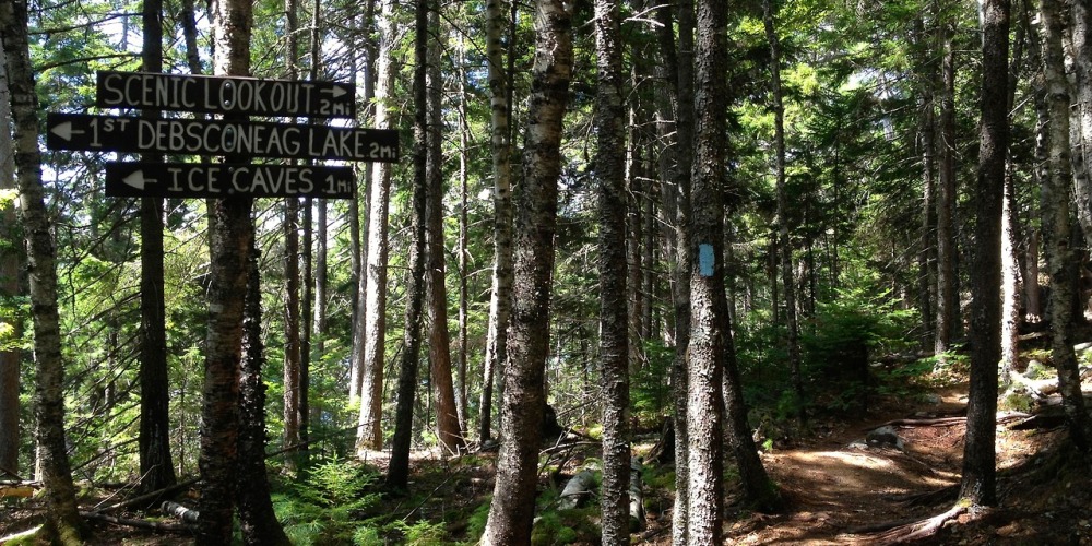
Turtle Ridge is a fairly new trail, constructed by the MCC (Maine Conservation Corps) about 8 years ago.  The trail is a figure-eight of sorts and can be done many different ways, so for my hike today I decided to wing it and go where I felt like hiking.  To get to the trailhead, I drove down Route 11 South from Millinocket to Jo-Mary Road. I drove in Jo-Mary, took the first fork toward Cooper Brook and drove through the Henderson Gate, about an hour and ten minutes or so from Millinocket.  The trailhead parking is well-marked, but the actual trailhead is not!

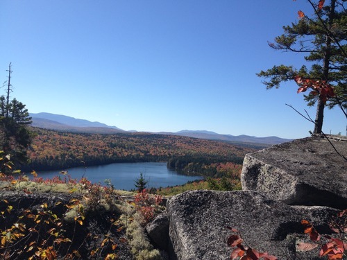
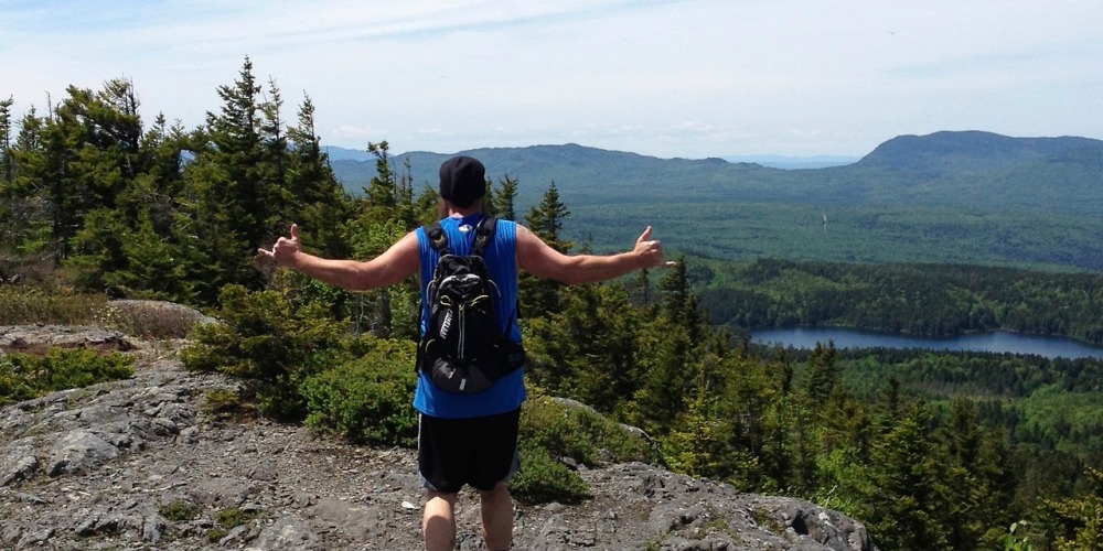
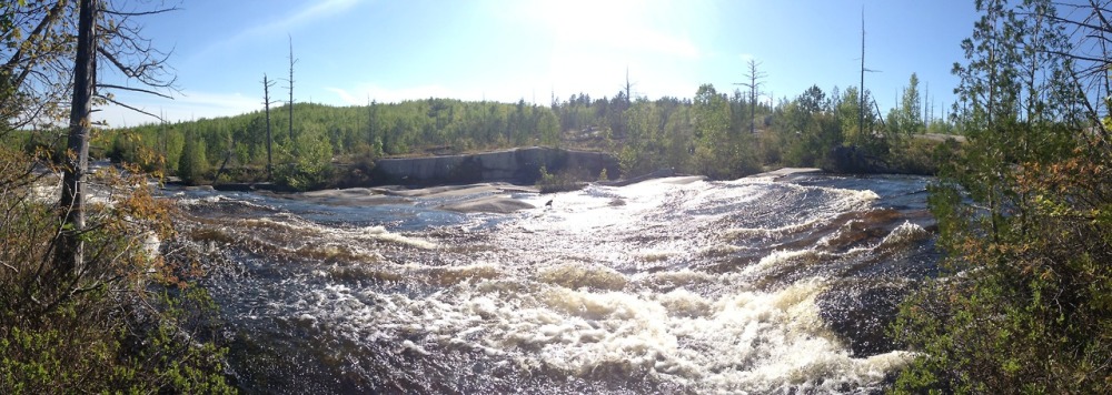
The trail is a blue blaze and begins a gentle uphill on soft, pine-covered trail and is in amazing shape.  After about a half mile or so you’ll come to a summit with the first trail junction and obscured views of other hill tops.  I decided to continue straight down to Rabbit Pond and a stream crossing.  There were a few ups and down, but all gentle or switchbacked for the next two miles or so until I came to Turtle Ridge, which looks down on Sing-Sing Pond and across the pond to the AT at the Whitecap Range.  There was a beautiful view here and I took some time for a snack and a few pictures before heading downhill to the next trail junction.  

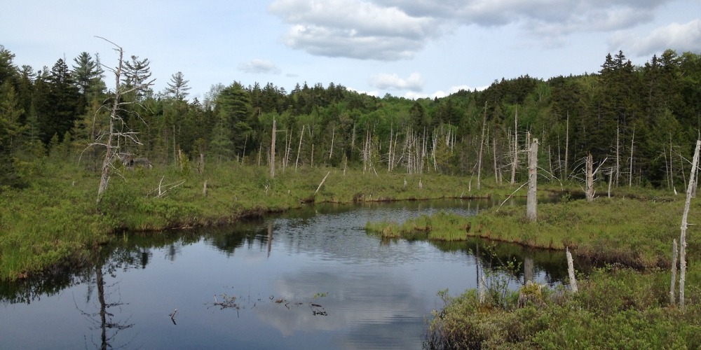
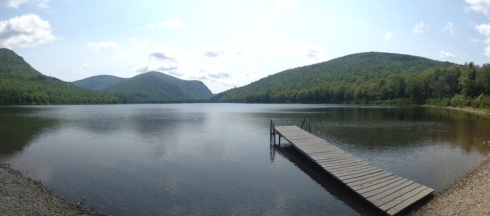
On the way down to the next section of trail (which is a second access point at ITS 85/86 (Musquash), there was a little bit more steepness but I had noticed some beautiful signs of fall with fresh fallen, colorful leaves underfoot.  When I reached the bottom of the hill, the trail turned into an old logging roadbed and was gentle and pleasant, following along the edge of Sing-Sing Pond.  I hadn’t seen a person or any wildlife all day so I was frightened by a moose who had seen me first and was taking off in the opposite direction and splashed into the pond! After a mild heart attack I began a steeper uphill that was more in Maine fashion than the rest of the trail to Long and Henderson Ponds.  This section of trail is more remote and, therefore, rockier and steeper than the first part.  I made my way uphill, stopping a few views and stopping once to ponder a green-blazed trail not on mine or any map I had seen before, slowly making my way down to yet another scenic pond.  

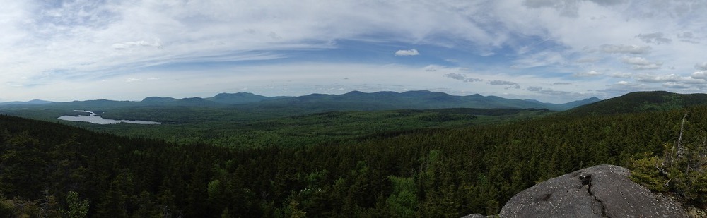
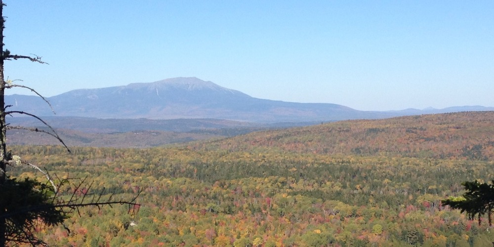
The last uphill of the day had some beautiful step work done by the MCC and a “scenic overlook” which turned out to be overgrown.  It was starting to get later in the day, around 3:15, so I was ready to be finished.  I was summiting my final hill when I came around a corner to the most stunning frontal view of Katahdin!  It was an amazing surprise!  To look down and see the ponds and little logging trucks snaking along Jo-Mary Road and then look straight ahead and see this beautiful mountain in the fall was stunning.  I had another snack break and took a few photos and videos before heading back downhill to the original trail junction and then, finally down to the car.  

Just before getting back to my car I had to walk along Jo-Mary Road for a quick minute.  I crossed a logging bridge and directly beneath me heard a splash… it turned out to be a beaver swimming through the small stream!  I stretched out and got ready to drive back to Millinocket.  After crossing the Henderson Gate I came to the Cooper Brook/AT junction of the road and saw two thru’s sitting on a rock looking exhausted.  They were dreaming of lunch at White House Landing, which was no longer serving lunch to hikers without a night’s stay (for the two of them, this would have cost around 90 bucks after the food and stay!)  I broke the bad news to them to find out they were pretty much out of food and looking forward to packing out burgers.  I had no food or trail magic, but offered to jump them ahead a day’s walk or so on the trail to Nahmakanta Lake if they wanted.  They gladly accepted and we drove the half-hour back in the other direction to the lake. 

They actually did stay with us at the hostel a few days later and gave me their blog to follow, even though they had already finished the trail. They were incredibly grateful, which was nice to see that late in the season. 

Katahdin from the top of the mountain:

The beaver in the stream: 

The view from Turtle Ridge: 

Recap of the past few months – late 2013 and early 2014

Since leaving Maine and moving to New York for a little while I haven’t had time to get much hiking done. Being that I’m now working two jobs to save up some cash and the fact that, despite it being mid March, there is usually a foot of snow on the ground at any given time, hiking has taken a backseat as of late.  I’ve done some exploring of the Central New York region, going snowshoeing at Beaver Lake, hiking at Clark Reservation, and exploring area greenways all while trying to find my way around the area.  One place I haven’t been yet is up to the Adirondacks!  I’m definitely looking forward to some warmer weather so getting up there won’t be such a big challenge. 

Speaking of big challenges, time to announce the next one of mine: Becoming a 46er!  Here in the Adirondacks, we have 46 peaks measuring 4,000 feet or higher.  Hike them all, you’re a 46er!  My challenge is going to be to peak bag all 46 this year, preferably before the end of autumn.  I’ve been doing some research on the area, as well as talking to people I work with who are or are actively on their way to being a 46er and learning all I can about permits, fees, etc. before embarking on this challenge in about six weeks.  I’m glad to say NoKey will be doing this with me to help us get in shape for bigger and bolder plans in the spring of 2015 (more on that at a later time!)

During the next few months, the blog will be busier again and I’ll recap all my hikes and backpack trips like I did before.  I feel sad I didn’t have the time to do so on all my hikes in Maine, but will be definitely making the time for it somehow as I document the trails of the Adirondacks.  I can’t wait to share my trips with you guys!

A few photos above: Snowshoeing for the first time at Beaver Lake; Max Patch in October 2013 on our roadtrip following leaving Maine; Katahdin from Turtle Ridge Trail in the 100-Mile Wilderness in Maine, October 2013. 

Today NoKey and I went hiking in Baxter State Park after more than a week of rain and being stuck indoors.  This was our first official hike together since we finished the AT more than 7 months ago.  We hiked north from the AT from the Abol Bridge after taking in the morning view.  There was a ton of snow as it had snowed up there Friday and Saturday nights.  We were able to keep dry feet for about 4.5 miles when we ran into a SoBo, our first official trail SoBo, who let us know that Neswadonahunk Stream was running high and we’d definitely have to take the high water trail.  Even this trail had high water!  We got our feet pretty wet before coming back to the AT and passing both Big and Little Niagra Falls.  We walked around Daicey Pond and were less than a mile from Katahdin Stream Campground when we thought we heard someone in the woods.  We kept going, but heard a voice behind us… it was Erick, a hiker who stayed with us for a few days waiting for the high water to receed before starting his section hike.  He made the statement “Only you two could make a SoBo hike north on the AT to catch you!”  We gave him half of a giant sub and some Little Debbie cakes for trail magic before we ran into another one of our hikers from the weekend, Stinky Jesus! (We named him SJ because a hiker came in hypothermic and he helped him take off his boots to help him into the shower.)  We gave SJ some trail magic too and wished him well for his hike.  

After getting to Katahdin Stream we decided to take a break, but the black flies and mosquitos were out in full force, so we kept moving on to the Blueberry Ledges Trail.  We had no idea what to expect on this trail, as we’d not ever really seen pictures.  Much of the trail was flooded for the first two miles and had been washed out quite a bit from all the rain last week, but we kept on until coming to the ledges, which were all granite rock with alpine plants.  The ledges go downhill to meet Katahdin Stream, which was running swift and high.  (Pictured above).  From here, we had a short 1.4-mile walk back to the AT near Abol Bridge and it couldn’t have been more pleasant, an old roadbed where we followed moose prints nearly the entire way down.  At the bottom of the trail we had another wonderful view of Katahdin and much of the snow melted in the direct sunlight and 70+ degree temperatures of the afternoon.  

It felt great to be hiking again back into Maine.  I can’t wait to get back into the 100 Mile Wilderness next time!

“Sometimes you will never know the value of a moment until it becomes a memory.” – Dr. Suess

This was me one year ago today, 11:00 a.m. at Springer Mountain in Georgia.  I had walked the 0.9 miles up to this plaque from the parking lot on the forest service road in about 15 minutes.  My head and my stomach were filled with butterflies as I took those steps, saying only “excuse me, excuse me” as I was passing the crowds of people going up to the southern terminus of the Appalachian Trail.  When I finally got there, I took a look at the view, got my photo taken (above) with the first white blaze of the AT, and then wrote a rambling, nonsensical, excited first journal entry in the log book.  This is it, 5 million steps until I quit.  

It was such a beautiful, warm, sunny day on March 27, 2012. My plan for the day was to walk until I felt like I didn’t want to do it anymore.  Even so early in the day, I was passing people setting up their tents for the day on the side of the trail and meeting lots of hikers.  The thing that really stuck out in my mind was how excited we all seemed, greeting everyone walking by with a smile and awkwardly listening to people trying to decide if they had a trail name or if they should use their real names.  I immediately began with using my trail name, feeling like it was a totally different persona.  People almost looked relieved when you gave them a trail name, as if to say “well, you’re doing it, so I can too!”  But enough with my first day memories!

I had no idea how much this day would completely change my entire life. You hike the AT and you know something is going to change. In fact, Warren Doyle (a 17-time thru hiker who holds seminars a few times a year) has been known to tell everyone he meets who intends to hike that if you don’t want your life to change you shouldn’t go.  I feel like one year ago today isn’t an anniversary of a journey beginning, I feel like it’s more of a birthday.  I discovered so many things about myself on this trip, even if it wasn’t apparent to me at the time.  I made life-long friends with people who I only knew for only a few days, which is mind-blowing to me.  We all supported each other and, in a way, became a family in a short period of time.  For all of those who were with me on the AT in 2012, be it as a thru hiker, a section hiker, or a trail angel, you helped me become the person I am today and sharing that portion of my life with you means a lot to me. 

In less than one month, I’ll be leaving my home in Knoxville behind to continue on my journey.  I’ll be moving to Millinocket, Maine to work at the Appalachian Trail Lodge for the hiking season.  If the job works out for the summer, it’s possible I’ll stay on year-round.  One year ago today I would’ve never guessed this would be my life.  I’m excited for all the changes and I can’t wait to share all my new travels and experiences with you.  

Flip Flop Flippin’ 2 – A documentary film about 2012 thru hikers!

While we were hiking in New York this year, we met a documentary film maker named Squatch.  He had hiked half of the AT last year, documenting the thru hikers and their stories and was back this year to finish his hike and do much of the same.  We only stayed with him twice, but we kept in contact with him and saw him again at The Gathering in West Virginia.  He was a lot of fun to talk with and had great stories from his own hikes on the PCT and the AT.  

Last week, Squatch released his film, “Flip Flop Flippin’ 2 – A search for character(s) on the AT continues…” and I immediately downloaded it to watch.  This film brought back so many wonderful memories for me, knowing nearly every hiker he featured this year.  At points in the film, there are hikers I hadn’t seen since 10 or 11 days in, hikers I never thought could finish the trail, and there they are in Maine only two weeks behind me!  

If you’d like to see the random things we talk about as hikers, the crazy stuff we do, or even the illness we put up with while hiking, I highly recommend watching the film.  You might even see a few hikers you know… (hint, hint!)  You can download the film directly to your computer or order a DVD or BluRay copy of the film at http://www.squatchfilms.com/

Check it out, especially if you were connected to the trail in any way in 2012!